Sunday 31 May 2009

Gwal Y Filiast, Carmarthenshire

(Click photos to enlarge).

The dolmem - or cromlech - of Gwal Y Filiast is quite well hidden away just outside of the small village of Llanglydwen in Carmarthenshire. To reach it you have to take a walk down a muddy track for about 10 minutes or so and take a turn into the woods.

It's very easy to get yourself lost whilst looking for this site. My father and I tried finding it one day during the Christmas holidays and ended up going too far and following the river and surrounding woodland for hours. We still managed to take a wrong turning today when we visited, although we knew the rough direction this time and soon got back on track.

Gwal Y Filiast - the name translates as Lair of the She-Wolf or Lair of the Grey Hound Bitch (not greyhound but grey hound - literally a hound that is grey - a wolf) - seems unusual for such a burial chamber being located in this setting beneath the trees.

The dolmen is at the epicentre of a ring a beech trees, while several other stones which may once have been part of the greater structure are scattered around the site. The dolmen itself consists of a huge capstone - easily 10 feet in length and 3 to 4 feet in thickness - balanced on four uprights, and there are a pair of smaller stones set in the ground at one end.

This is a really atmospheric site, which is in no doubt enhanced by its surroundings on the wooded slope above the river Taf. It is a little off the beaten track and is unlikely to be visited by casual tourists, who would be far more likely to head for somewhere better known in the general area such as Pentre Ifan. I think they are missing out! Remember to consult a map if you want to visit and wear walking boots or wellies!

Date visited: 31 May 2009.

See also: Gwal Y Filiast on The Megalithic Portal
Gwal Y Filiast on The Modern Antiquarian

Thursday 21 May 2009

Portchester Castle, Hampshire

(Click photos to enlarge).

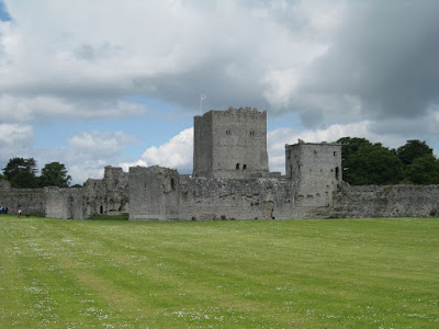
Portchester Castle, which sits overlooking the eastern end of Portsmouth Harbour, is a medieval castle, palace and former Roman fort.


It all seems so much bigger once you get inside the inner walls of the main castle.


Pictured below is one of the castle's current residents.

St Mary's Church (below), dating back to Norman times, sits in the south east corner of the complex within the outer castle walls.

Here is another photo looking down at the ruins from on top of the keep, which is a whole lot higher than it first appears to be!

Proof that graffitti is no modern phenomenon.

All in all, this is a very nicely kept site and is well worth the admission fee. Like Doctor Who's TARDIS, it's a lot bigger on the inside than you may at first think. Personally, I didn't care for the audio tour (which is included as part of your admission fee), finding the actors doing silly voices extremely tedious, and I also prefer to make my own way around at my own pace and not have the tour dictated by a piece of technology. However, it may appeal to you, especially if you want a potted history. The other alternative is to read up about the history separately.

Date visited: 21 May 2009

See also: Portchester Castle
A Guide to Portchester Castle
An Interactive Guide to Portchester Castle

Saturday 18 April 2009

Fishguard Fort, Pembrokeshire

(Click photos to enlarge).

From the information sign outside the fort:

"The fort was built following a raid on Fishguard in 1779; the privateer vessel Black Prince demanded £1,000 to return a captured local ship and as a ransom for the town. When this was refused it bombarded Fishguard, damaging St. Mary's Church and some houses.


"As Fishguard was a prosperous port, protection was vital. The fort was completed in 1781; armed with eight 9-pounder guns manned by three invalid gunners from Woolwich, it became the headquarters of the Fishguard Fencibles.


"On 22nd February 1797, an invading French force appeared off the coast. Alarm guns were fired from the fort, but the Fencibles were withdrawn from the building which played no further part in the invasion.


"Following the end of the Napoleonic Wars in 1815, Fishguard Fort fell into disrepair. It is now owned and maintained by the Pembrokeshire Coast National Park Authority."


Below is a view of the fort as seen from the other side of the harbour.

Below is a view of what is now known as Lower Fishguard and the actual harbour that was being guarded. This is not to be confused with the much larger commercial harbour from which the ferries to Ireland depart.

Date visited: 10 April 2009.

Saturday 11 April 2009

The Church of St Brynach, Cym Yr Eglwys, Pembrokeshire

(Click photos to enlarge).

When I was a small child, we used to holiday at a farm near Dinas Head in Pembrokeshire, and as a family we would trek almost daily from the farm to the nearest beach at Cwm Yr Eglwys. We spent many happy hours playing there. It was a fantastic beach for bathing in the sea and for its many rock pools waiting to be explored. Set in a secluded bay, Cwm Y Eglwys is said to have its own micro-climate and is supposedly a few degrees warmer than elsewhere on the Pembrokeshire coast.

One of the main distinguishing features at Cwm Yr Eglwys beach is the ruins of the 12th Century church of St Brynach. Most of the church was destroyed in the almighty storm of 1859, and much of the ground that it was built upon and graveyard was also swept away.

Above: The old parish church of Dinas, Pembrokeshire, prior to its destruction in the 1830s. Scan of a hand-coloured print dated 1830. Copyright expired: from "Wales Illustrated", Jones & Co, London, 1831. Painting by Henry Gastineau (1791-1876). Engraved by Edward Kennion.

By the entrance to the churchyard, we find this memorial - a model brig consructed in metal by James Eifion Thomas, Blacksmith, of Dinas Cross. The plaque reads:
The Cwm Trader

This is a scale model of a coastal trading brig, typical of those that plied the waters of Pembrokeshire and Cardiganshire about the time when St Brynach's Church in Cwm-yr-Eglwys was destroyed in the Royal Charter storm of 1859. These vessels were of relatively shallow draft and largely flat bottomed, so allowing them to be sailed into bays at high water and then unloaded at low tide by horse and cart transport. Many of these vessels were lost in that fateful storm and this model is erected as a memorial to those sailors and their ships and to mark the occasion of The Millennium.
Date visited: 10 April 2009

Tuesday 17 March 2009

St Andrews Church, Church Ope Cove, Portland

(Click photos to enlarge).

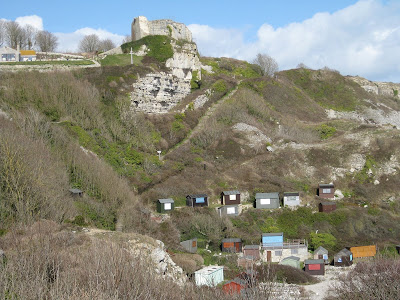
The ruins of St Andrews Church are situated halfway up the cliffside above Church Ope Cove on the eastern coast of the Isle of Portland in Dorset.

Overlooked by Rufus Castle, St Andrews was originally built between 1150 and 1470 and served as the parish church of Portland until the mid 1700s.

The church was damaged following a landslip in 1675, but it wasn't until 1756 that the church was finally closed, and when stones were taken away to help build St George's Church at Reforne.

According to local legend the graves include those of several pirates, although we were unable to make out any of the lettering on the tombstones due to weathering and so couldn't pinpoint quite where their resting places might be. Another story I have heard is that it was French pirates who, along with the landslips, helped destroy the church.

Below we see another picture of Rufus Castle, looking across Church Ope Cove. The cove is now a popular site for fishermen and is home to many beach huts, although it was quite empty when we visited. The beach, which is absolutely strewn with pleasingly round stones and boulders of the grey Portland stone, seems to be quite a tranquil place and it must be a far cry from the days of attacking pirates and the smugglers for which the beach is famous.

Date visited: 9 March 2009

Wednesday 11 March 2009

Lighthouse, Pulpit Rock & Sea Caves, Portland Bill, Dorset

(Click photos to enlarge).

Portland Bill lighthouse was built in 1906 and is 35 metres (115 ft) tall. There are two earlier lighthouses relatively nearby, one of which is now a bird observatory.

Portland Bill itself is the promontory of (the eponymously named) Portland stone at the southern tip of the Isle of Portland, off the coast of Dorset in South England. Portland isn't quite a true island in that it is connected to the mainland by the sandbank formed by the eastern end of Chesil Beach (which is itself 18 miles long).

Everywhere there is evidence of the isle's history of quarrying. There are piles of Portland stone at regular intervals, and as you follow the coastline around you encounter various abandoned quarries. Near to the lighthouse is an enormous structure jutting out into the sea, known as the Pulpit Rock (pictured above). This is in fact a man-made structure formed by the quarrying process.

It's hard to tell in some parts whether the jagged coastline of Portland has been cut away by men and machines or if it has been naturally eroded. To the east of the lighthouse and approximately half a mile away there are some huge sea caverns that have, presumably, been eroded out underneath the land above by the sea.

My guess is that they were formed by a natural process, as it looks to be a very peculiar way in which to quarry stone - but if you know differently, please let me know! One of the sea caves is viewable from above through a hole in its "roof" which has a grill laid across it formed from sections of railway line.

Date visited: 9 March 2009

Tuesday 10 March 2009

Durdle Dor, Dorset

(Click photos to enlarge).

Durdle Dor - or Durdle Door which might seem to be the more logical spelling - is a natural limestone arch on Dorset's Jurassic coast located between Lulworth to the east and Weymouth to the west.

The photo below is taken from the east and shows the Man O'War beach on the other side from the limestone arch, and you can also see quite nicely how the bands of rock continue straight through the main structure.

Note Portland on the horizon in this and the first picture.

See also: Durdle Door on Wikipedia

Visited: 9 March 2009

ShareThis