Friday 23 January 2009

The Dashwood Mausoleum, West Wycombe, Buckinghamshire

(Click photos to enlarge).

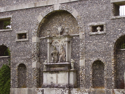
The Dashwood Mausoleum, built in 1765, is a vast monument constructed of Portland stone and flint. Sitting at the summit of West Wycombe Hill in Buckinghamshire (which is also the site of an Iron Age Hill Fort), the mausoleum houses the urns containing the ashes of the Dashwood family, the most notorious of which was Sir Francis Dashwood, 15th Baron le Despencer (1708-1782).


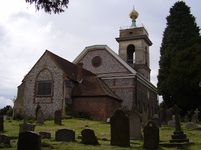
Behind the imposing hexagonal structure of the mausoleum sits St Lawrence Church (below). The church tower is very oddly topped off by a golden sphere, which apparently is big enough to hold up to eight people, and is said to have been formerly used for secret meetings.


Of course, beneath all this and inside West Wycombe Hill itself are The Hellfire Caves which are possibly worthy of their own blog entry.

The following is a short music video that I made using stills and footage captured during this visit:


Date visited: 16 August 2008

Wednesday 21 January 2009

Belas Knap, Cleeve Hill, Gloucestershire

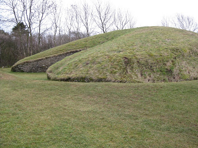
From the Rollright Stones we decided to visit Belas Knap, a long barrow on Cleeve Hill near Cheltenham, as it was - supposedly - only half a hour's drive away. However, we encountered a hunt (a drag hunt, I sincerely hope) and the journey was extended another half hour.

(Click photos to enlarge).

From the parking space down on the road, it was quite a slog walking half a mile uphill to the site of Belas Knap.


From the sign pictured above:
"Belas Knap is a shrine built around 2500 BC. It was used for successive burials, possibly over a period of several centuries, until eventually the burial chambers were deliberately blocked. The chambers contained the remains of 38 human skeletons, together with animal bones, flint implements and pottery.

At one end is a false entrance which although impressive leads nowhere. It may have been intended to deter robbers or evil spirits or to have some symbolic significance. The space in front of this was probably used for rituals and ceremonies.
"
The false entrance at the north of the barrow is pictured below:


The entrance to the North West chamber:


Inside the North West chamber, looking out:


The entrance to the sealed South chamber:


The South East chamber (below). I didn't fancy going inside this one...


...because as you can see, there's not exactly a lot of headroom:


The North East chamber contains several standing stones:


Inside the North East chamber, looking out:


I have to say, that in parts - especially around the north "false" entrance this site looks quite modern, although I understand it has been restored, and in the chambers that I entered there was evidence of concrete in the ceilings. It makes me wonder what condition Belas Knap was in before restoration. Nevertheless, it's a great site to visit, but be prepared to exert yourself getting there!

Date visted: 17 January 2009

See also: Belas Knap on The Modern Antiquarian

Sunday 18 January 2009

Long Compton Church, Warwickshire

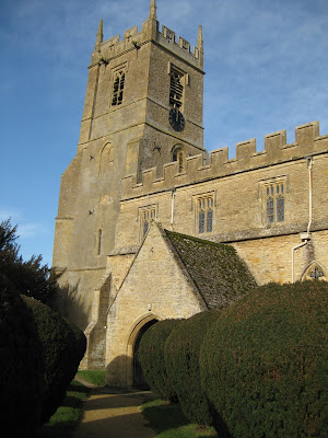
On our way to the Rollright Stones we stopped in the nearby village of Long Compton. The church there has one of the most unusual-looking lych gates that I have ever seen, as it appears to have a small house over it.

(Click photos to enlarge).

According to a sign posted on the notice board beneath the lych gate:

"The parish lych gate dates from about 1600, when it was the end of a row of cottages. Most of these were demolished in the 1920s. The lych gate became first a cobblers and later an antiques shop in the middle of the last century.

It was re-roofed and restored by a past resident, Mr George Latham, and given to the Church as a memorial to him by his wife, Marion, on 12th November 1964. The room above the gate is loaned to the Compton District History Society.
"


In the porch to church itself we find this stone figure (pictured below) of a rather peculiar-looking woman. Her almost featureless face with its wide apart blank eyes puts me in mind of the modern-day popular image of an alien "grey".


Another posting on a notice board tells us:

"Beside the door into the Church there is a stone effigy of a woman. It dates from the 15th century. She is wearing an ornate headdress and you can just make out a small dog resting at her feet. The effigy was probably the cover of a tomb, and originally located in the north aisle."

Another theory that the church avoids mentioning is that the figure is that of a witch. It has been suggested that the animal at the figure's feet may be the witch's familiar: a cat or a fox.

Interestingly, Long Compton seems to have a history of witchcraft as a quick Google search will show. For example, local legend tells that the Rollright Stones are the remains of a King and his army who set out to conquer England but the King was hailed by a witch who told him to take seven strides and then:
If Long Compton thou canst see
King of England thou shalt be
The King took seven strides but instead of seeing Long Compton he saw a spur of land obstructing the view. The witch said:
As Long Compton thou canst not see
King of England thou shalt not be.
Rise up stick, and stand still, stone
For King of England thou shalt be none.
Thou and they men hoar stones shalt be,
And I myself an eldern tree
Date visted: 17 January 2009

The Rollright Stones, Oxfordshire/Warwickshire border

(click photos to enlarge).

Yesterday I visited The Rollright Stones in North Oxfordshire near to the village of Long Compton.


The stones are actually split over three separate sites:

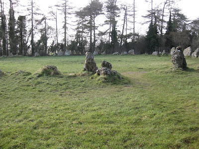
The stone circle is popularly known as The King's Men and is thought to date back to late Neolithic or early Bronze Age. It is 33 metres in diameter and consists of about 70 stones.
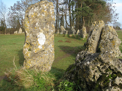

It is said that you cannot accurately count the stones that make up The King's Men, as the total will be different each time. We tried this on a previous visit and indeed we had trouble deciding on a total - but part of the problem is deciding what constitutes a single stone where perhaps a stone has cracked or been broken, or else where what appears to be two stones might just be the same stone beneath the surface.

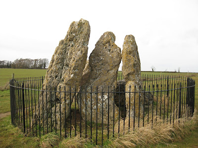

The Whipsering Knights (above) appear to be a small grouping of standing stones huddled together as if holding a private conversation; it is believed that this formation is the remains of a collapsed burial chamber. There are four uprights and a large recumbent stone which was probably the capstone. These are situated to the east of The King's Men and just a short walk away.
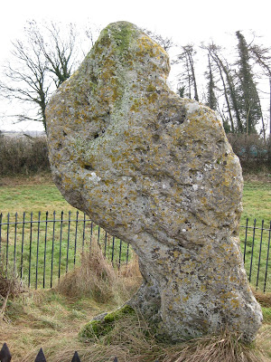

Finally, just over the road from The King's Men and over the county border too and into Warwickshire, is a lone standing stone called The King's Stone (above). It is a very peculiar shape, although this is partly because in the days before it had a fence erected around it vistors would chisel off chunks of it to keep as souvenirs!


In the past The Rollright Stones were one of the few ancient monuments that I have visited where you have to pay a (small) entry fee. I have absolutely no problem with this. The fee, of course, went to the upkeep of the site. There used to be a hut at the entrance where an affable old gentleman would take your entrance fee and would tell you about the stones should you have any questions. He would even lend you a pair of divining rods if your interests and beliefs lay in that direction.
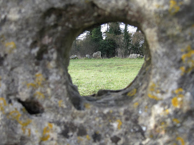

But unfortunately we live in sorry times. The old man and the hut have gone. The old man has sadly died and the hut was burnt down by vandals. Vandals have attacked the stones on various occasions, covering them in yellow paint on one occasion, and burning them on others. Obviously, these acts of mindless destruction mean expensive and painstaking clean-up work. What I find most alarming is that these are not random acts of vandalism but that they must have been pre-meditated. Someone has specifically made the journey with the express intention of attacking the stones.


On this visit there was no-one collecting entry fees. I didn't even see a box for donations.I am hoping that the Rollright Trust and/or the Friends of The Rollright Stones have not thrown in the towel and given up. I thought they had been doing an excellent job. What other group of stones has its own website? I like that you can download an audio tour and play it on you iPod as you walk around the stones.

To sum up, this is a lovely site which needs your support.

Date visted: 17 January 2009

See also:

Monday 12 January 2009

Carreg Coetan Arthur, Newport, Pembrokeshire

(Click photos to enlarge)

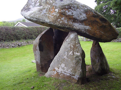
Here's another site in Pembrokeshire that I visited on one of the few days in July 2008 on which it didn't pour down with rain. Carreg Coetan Arthur is a Neolithic dolmen and is situated where you'd least expect it - next door to a couple of bungalows in a residential close in the small coastal town of Newport, North Pembrokeshire.


The juxtaposition of this ancient dolmen sitting amidst the 20th Century bungalows somehow seems to make it all the more magical. It's quite literally a little piece of our ancient history in someone's back yard!


To give you an idea of scale, in the next photo are my niece and nephew.


As you can see, it's nowhere as huge as Pentre Ifan, but it's still an impressive site and like that other dolmen its massive capstone seems to defy gravity, almost hanging in the air over the four upright stones.

Date visited: August 2008

See also: Carreg Coetan Arthur on The Modern Antiquarian.

Saturday 10 January 2009

Carnedd Meibion Owen, Ty Canol, Brynberian, Pembrokeshire

(Click photos to enlarge)

Returning to the Preseli mountains again, just south of the Ty Canol woods and a couple of miles south west from Pentre Ifan, on a bleak hillside arranged in a line running roughly north to south are four cairns known as Carnedd Meibion Owen.

According to Best Walks In Southern Wales by Richard Sale, the site "is named for the three sons of Owen who decided to fight for their father's land, even before he had died rather than divide it between them. [...] They made wooden clubs and fought all day on the hill, but as night fell no one had won. Eventually the father chose one son, sending the others to be the kings of England and Scotland."


From a distance it's difficult to judge the scale of what looks to be a few rocky outcrops. It's only when you get up close and take a walk around them that you realise how truly monolithic these cairns are.


But what are they? Are they geological features, are they man-made, or are they a combination of the two? They certainly resemble some of the rock formations found in Snowdonia in North Wales where glacial action has shattered and splintered the rocks.


I've read elsewhere that "Recorded archaeology comprises two possible neolithic chambered tombs", although this does little to explain why there are four cairns.


This is a stange and quite breathtaking site where you really do feel that you are encountering the unknown. It's well worth a visit and just a short distance away from Pentre Ifan on the more popular tourist trail. Unlike Pentre Ifan this site is unlikely to be swarming with tourists and hoardes of kids. It very likely will be just you and the wild ponies.

Date visited: 31 December 2008

Wednesday 7 January 2009

"Celtic" Cross, St. Cledwyn’s Church, Llanglydwen, Carmarthenshire

(Click photo to enlarge)

Here's another stone in a churchyard. This rough "Celtic" cross is to be found just inside the entrance of Llanglydwen Church in Carmarthenshire and - according to the Crymych Group of Churches website - it is believed to date from between the 7th and 9th Centuries. (St. Cledwyn's Church itself dates back to the 13th Century). Note the carving on the front of the stone.

Date visited: 27 December 2008

Monday 5 January 2009

The Ogham Stone, Glandwr Chapel, Pembrokeshire

(Click photos to enlarge)

In the last couple of weeks I've visited various standing stones and sites around Pembrokeshire in Wales, but the one which I'm featuring in today's post was the easiest to visit for me personally seeing as my parents live in this very village.

The Ogham Stone is to be found in the grounds of the chapel in a village called Glandwr, situated at the foot of the Preseli mountains, and with the nearest town being Crymych.

As can be seen in the above picture on the left hand edge of the stone when looked at from this angle there are a series of Ogham markings cut into the stone. Unfortunately I can't translate these for you. One theory I have heard is that Ogham is actually a musical notation.

Just behind the Ogham Stone is another little curiosity that the visitor might like to take a look at, although this time it's hardly ancient.
The gravestone of Lewis Phillips states - in Welsh - that he died on June 31, 1900. Now how does that rhyme go again?... Thirty days have September, April, June and November...

Date visited: 31 December 2008

See also: Glandwr Churchyard on The Modern Antiquarian

Sunday 4 January 2009

Gors Fawr Stone Circle, Mynachlogddu, Pembrokeshire

(Click photos to enlarge)

To the South West of Mynachlogddu in the foothills of the Preseli mountains lies the fantastic little stone circle of Gors Fawr. Looking at the spectacular scenery in the photo above you'd be forgiven for not noticing the stone circle (despite the sign saying its there) because most of the 16 stones making up the 22 metre diameter circle are under two feet in height and so the circle might not be immediately apparent.


If you are planning a visit to Gors Fawr it is worth bearing in mind that the land around the stone circle is quite marshy, so depending on time of year, you might want to wear the appropriate footwear (eg, Wellington boots). We visited on 27 December 2008 which was a glorious but very cold day. The ground was quite hard and frosty which made the terrain much easier to negotiate than perhaps it is at other times of the year.


To the north east of the circle lie two additional stones (pictured below) aligned to the Solstice, and one of these is known as the Dreaming Stone and allegedly has magnetic properties. I personally didn't experience any magnetic effects and my camera behaved itself (unlike the time I tried taking photos of the Rollright Stones in Oxfordshire and found that a good number were almost completely whited out).


Animal lovers will be interested to note that this is a good place to see some of the wild ponies that roam the Preseli mountains. I snuck up behind a tree and managed to get a lovely shot of this fellow in the photo below.


All in all I'd say that Gors Fawr was well worth a visit and is probably my favourite ancient site out of those we visited in Pembrokeshire over the last week.


Date visited: 27 December 2008

See also: Gors Fawr on The Modern Antiquarian

Meini Gwyr, Glandy Cross, Pembrokeshire

(Click photos to enlarge)

Glandy Cross is a small relatively-modern village straddling the crossroads with the main through road being part way between the towns of Clunderwen and Crymych. The local garage/convenience store ensures that it quite a busy little place. But Glandy Cross has a much older history with numerous standing stones and barrows in the immediate vicinity. The most accessible of these is what remains of the stone circle known as Meini Gwyr sitting in a plot of land behind one of the bungalows opposite the garage. Sadly, there are only two of the original stones remaining in the circle, but the raised ring of the bank on which the stones of the circle once stood can be clearly seen on the ground.


The text on the information sign pictured above (supplied by the Dyfed Archaelogical Trust Ltd) reads as follows:

Meini Gwyr, also known as Buarth Arthur, is an embanked stone circle probably dating to the transition between the late Neolithic and early Bronze Age periods (c.2000BC). The site is likely to have been used for religious rituals.

According to a late 17thC account by Edward Lhuyd, there were then fifteen stones in the cirlce ranging in height from three to six feet, but a further seven or eight were thought to have been 'carried off'. Apparently, there was also an entrance lined by smaller slabs.

The site was partially excavated in 1938 by Professor W.F. Grimes. Unfortunately most of the records were destroyed in a bombing raid on Southampton in 1940. The plan is based partly on ground and air photographs of the excavation. Grimes established that the circle, some 60 feet in diameter, originally consisted of 17 stones which, like the two surviving ones, were set at an angle into the inner slope of the bank about 3 feet hight and 120 feet in the external diameter, with no trace of a ditch. The excavations confirmed that the entrance through the earthwork was formerly flanked by upright stones, set in a trench. The bank was set with stone curb extending for some 30 feet on either side of the entrance, in front of which was a clay-filled pit containing a large quantity of charcoal. There were no features or finds recorded from the interior, though this was only partly examined. Some fragments of early Bronze Age pottery came from a hearth set in a deep depression on the southeast bank.

Meini Gwyr stands at the centre of 'West Wales' most important complex of Neolithic and Bronze Age ritual and funerary monuments, lying on a ridge-way linking the wester end of the Preselis to the eastern Cleddau river and Milford Haven. This was a route by which the bluestones for Stonehenge may have been transported. Included in the complex are several Bronze Age burial mounds and cairns or various forms, and a 'henge' monument (akin to early elements at Stonehenge). Also, there is the site of 'Yr Allor' ('The Altar') comprising two, formerly three standing stones some 200 yards west of Meini Gwyr and apparently known by the 17thC. These stones may be the remains of a chambered tomb.

Carn Meini, a source of the bluestones lies only 3 miles to the north. The site's name - 'Meini' ('large stone') and 'Gwyr' ('crooked') may refer to the varying size, shape or angle of the stones set in the circle. These were not 'bluestones' but another form of volcanic rock. Many such boulders are found locally and were originally depostited by glacial action. The alternative name 'Buarth Arthur' ('Arthur's Yard') is an example of a common legendary association of this figure with prehistoric stone monuments and is not regarded as significant.


Date visited: 27 December 2008

See also: Meini Gwyr on The Modern Antiquarian

Saturday 3 January 2009

Pentre Ifan, Pembrokeshire

(Click photos to enlarge)

I'll start with what is perhaps the best known ancient site in the area of South West Wales, the dolmen known as Pentre Ifan which is to be found in the lower Preseli Mountains a few miles south west of Newport. (Note Carningli in the background of the above photo).

This is a popular site and is the one that everyone seems to know about despite there being a wealth of other fantastic sites seemingly peppered all across the county and most of which go practically unvisited. When we visited on New Year's Eve there were already three car-loads of people there plus some hikers. There were guys laden with the most expensive looking photographic equipment trying to take photographs whilst squadrons of small children bombed about the place, running in and out between the upright stones. Thankfully once the kids had left I was able to rattle off a few photographs of my own.
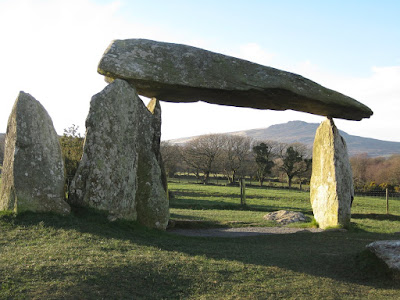
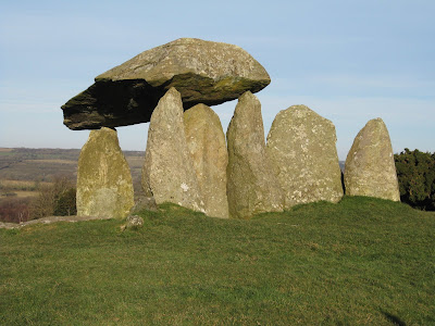
One of the reasons that Pentre Ifan is so popular with the tourist crowd is that it really is quite impressive. It is the tallest such monument in the region and the capstone almost seems to defy gravity as it seemingly balances on knife-edge points on three of the uprights.


Supposedly most of this structure was once covered over with soil with only the side in the above photo open to the elements. Some other stones are no longer in their original positions and can be seen scattered around the site.


The above photo was taken circa 1970/71 and shows that I too was once a small child who liked playing amongst the stones of Pentre Ifan whilst my Nana and sister pose nicely for the camera.

Date visited: 31 December 2008

See also: Pentre Ifan on The Modern Antiquarian

ShareThis